Uttarakhand, earlier known as Uttaranchal, is a hilly state situated in the North of India. Dehradun, the capital of Uttarakhand, is also known for its beautiful surroundings, as it lies in the Doon Valley. The state has a total area of 53,483 sq km and is mainly divided into two parts; Garhwal and Kumaon. The state is also famous for its rich natural resources, dense forests, glaciers and snow-clad peaks.
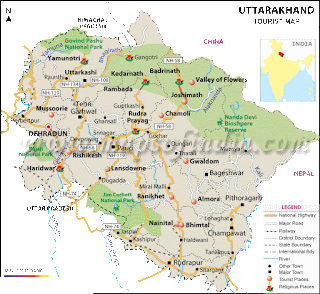 Uttarakhand, well-known as the "Land of the Gods" or "Dev Bhoomi", has the most sacred Hindu temples or the Char Dhams - Badrinath, Kedarnath, Gangotri and Yamunotri, in the state. The state is the point of origin of the most sacred and famous rivers of the country, Ganga and Yamuna. Uttarakhand also houses the "Valley of Flowers", which is also a UNESCO World Heritage Site.
Uttarakhand is home to all the famous hill stations of northern India, such as Nainital, Uttarkashi, Mussoorie and Chamoli. The dense jungles of Uttarakhand make it a perfect home for 12 National Parks and Wildlife Sanctuaries.
Besides the picturesque views of the hills, religious destinations, the state also offers various adventure sports such as trekking, climbing, and water rafting.
Comments
Post a Comment